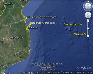
Mozambique Channel Hideaway near the Bazaruto Archipelago
Published 9 years ago, updated 6 years ago


Only recently I was able to talk in detail to a cruiser who spent 10+ years in the Bazaruto Archipelago – a group of six islands in Mozambique, near the mainland city of Vilankulo – about an alternative hide away in
that region.
A bit of background
The spot is generally known as Bartholomew Diaz/Diaz Point and is a sheltered river mouth which is protected by a spur of land projecting in an easterly direction from the mainland and then extends north protecting the river with sandbars and some dry land.
Up until 2007, this spur of land had a road on it leading to a lodge built on one of the substantial “islands” connected to the mainland with extensive sandbars etc. The area was ravaged by a cyclone in 2007/8 which destroyed the access road and the lodge and remodelled the entire area to the extent that it has taken close on 10 years for nature to put it all back together. It is only in recent times that the local yachties have been frequenting this spot during extreme weather and is now a viable alternative to the shelter behind Bazaruto.
Advantages
Apart from the shelter, it is removed from the islands and being isolated takes the yachties out of reach of the corrupt officialdom.
In addition, when the weather turns, it is a lot less complicated to get out from a time point of view and head south.
Interestingly, this spot was used by Japanese submarines as a refuelling stop during WW2 and I had the opportunity in 1969 during my first visit to Vilanculos to meet the son of the guy who was involved. He was the owner of the Donna Anna Hotel in Vilanculos, which he inherited from his father.
Waypoints
1 21 04.3805 S 35 07.3633 E
2 21 05.3079 35 07.5864
3 21 06.0927 35 07.5897
4 21 06.9542 35 07.0319
5 21 07.5948 35 06.6061
6 21 07.9150 35 06.0791
7 21 09.0629 35 06.3023
8 21 10.5453 35 06.9203
9 21 11.9091 35 06.8893
10 21 13.1445 35 06.7623
11 21 14.2678 35 06.5873
12 21 14.9365 35 06.3125
Anchorages
1 21 08.8580 S 35 06.6215 E
2 21 15.4741 35 06.5187
The normal caveats apply as far as entering/exiting only on an incoming tide and visual navigation is required paying particular attention to draft and depth.
Des Cason
Des and Nell Cason used to run the Madagascar relay station for the Peri-Peri net. Although no longer resident in Madagascar, Des and Nell have sailed this area extensively and welcome the opportunity to stay involved in the well being of fellow sailors. Contact them by E-mail at sygambit@gmail.com
Related Reports:
Related to following destinations: Madagascar, Mozambique, South Africa


Update from Des Cason (author of this article) – March 7th, 2018:
We will have to rethink some of my recommendations regarding shelter in Mozambique, and specifically at Bazaruto, as some of this years crowd had some unpleasant experiences with the officials resulting in the seizure of passports and exorbitant fines/bribes being demanded. I will let you have more detail on this shortly once I have done some more research and have clarified my thoughts in this regard.
Having sailed up to BD as this area is commonly called in December 2017 I came to realize for a sailboat it’s a long slog to get to a protected anchorage as most of the beach outcrops have been eroded away. The closest land for protection is 10nm from the entrance to the “mouth” but because of the shallows and the southerly blowing we had to use motors to push us against the wind and seas arriving at the protection in just over 2 hours so it was hard work. I would still recommend Bazaruto which is far easier